Mickiewicza Waterfalls – Morskie Oko – Rysy
![]()
Difficulty Level: ****
Walking Time: 5h 55′ (9,5 km)
![]() 1524m (5000ft)
1524m (5000ft)
![]() 193m (633ft)
193m (633ft)
Climbing Features – Metal chains & brackets
Highest Point: Rysy – 2499m (8199ft) a. s. l
The bus from Zakopane to glade Palenica Bialczanska takes about 40 minut and the service terminates at a large car park. The road to Morskie Oko is paved, except for a few shortcuts on the serpentine just before you reach the Dolina Rybiego Potoku (Fish Brook Valley).
It’s worth noting that carriage rides are available between Palenica and glade Wlosienica, from which it takes only about 20 minutes to get to Morskie Oko. After about a half-hour walk we come to Mickiewicza Waterfalls, where our route intercepts the green marked trail running from the shelter in Roztoka to the Five Polsh Lakes Valley. We cross the bridge over one of the three waterfalls.
After another half-hour hike we come to a shortcut, which allows us to bypass the weaving road through the forest as we overcome the threshold separating the Dolina Białki (Bialka Valley) from Dolina Rybiego Potoku (Fish Brook Valley). The trail reconnects to the road just before we reach Wlosienica which offers a magnificent panorama of Mieguszowieckie Summits, Cubryna and Mnich.
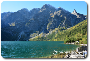
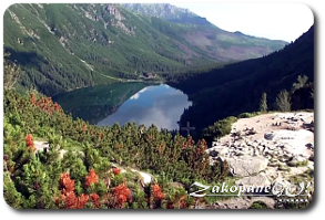
Keep in mind that this section of the journey is particularly vulnerable to avalanches if hiking in the winter season, when a bypass is created on the left side of the trail to avoid risks. The remaining part towards the shelter should take no longer than 25 minutes, with the entire trek from Palenica Bialczanska taking us a little over 1.5 hours in total. Morskie Oko is the largest lake in the Tatra Mountains, at an altitude of 1395 m above sea level and an area of 34.93 ha, length of 862 m, 568 m in width, and the deepest point reaching 50,8 m. The surrounding peaks rise over 1,000 metres above the surface. The aim of our expedition is the highest peak in the area – Rysy – shifted slightly to the south when looking from the lake as the surroundings are dominated by Mieguszowiecki Szczyt and the vertical wall of Kazalnica. From the lake we have a choice of trails onto Pod Chlopkiem Pass, Wrota Chalubinskiego Pass , Szpiglasowa Pass and Dolina Pięciu Stawów Polskich (Five Polish Lakes Valley) by Swistowa Czuba and, of course, Rysy. Here begins a truly alpine part of our journey. We set off from the shelter (1395m) and then, on the opposite bank, begin the approach to the threshold separating the Morskie Oko and Czarny Staw (Black Lake). At the same time we have the opportunity to admire the incredible clarity and transparency of the waters of Morskie Oko.
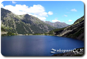
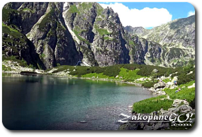
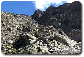
After reaching the opposite bank, the trail turns left and continues steeply uphill. After about 40 minutes from the hostel we reach the shores of the Czarny Staw ( Black Lake – 1583m a.s.l). The green trail to the Przełęcz Pod Chłopkiem (Pod Chlopkiem Pass) peels off to the right. Our trail leads to the left side of the pond, and after about 20 minutes begins to climb steeply uphill. A little over 30 minutes later, the zigzags bring us to a large boulder, overlooking Czarny Staw and part of the Morskie Oko and about 20 minutes later reach Bula pod Rysami (2054 m) from which we can expect an hour’s climb towards the summit, made easier by a set of chains.
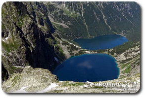
Parallel to us on the right side of us is a gully filled with snow, stretching from the top of Rysy earned their name. Some beautiful views of the Morskie Oko, Czarny Staw, Mieguszowiecki Szczyt, Kazalnica and further in the distance, Swinica and Kozi Wierch (Chamois Peak). After reaching the ridge, the trail turns to the right and with the help of buckles and chains, takes us to the summit. A short section of the trail along the ridge leading from Rysy is the most exposed portion of the entire route.
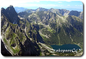
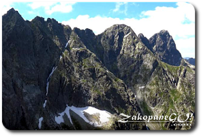
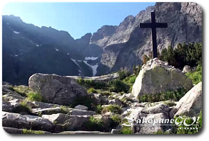
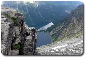
The trek from Rysy to Czarny Staw takes approximately 2,5 – 3 hours, from Morskie Oko about 4 hours. View from Rysy covers all the major peaks of the Tatra including Gerlach, Lodowy, Lomnica, Wysoka. The highest situated chalet in the Tatras – Slovak shelter is also visible here. A few dozen meters from the top of the Polish summit rises the tip on the Slovak side (2503m). At the top there is a border crossing open during the summer season. Return by the same route or a much easier descent taking you over to Slovakia.
 View from Rysy