Hala Gasienicowa – Krzyzne Pass
![]()
Difficulty Level: **
Walking Time: 3h 00′ (5,2 km)
![]() 729m (2392ft)
729m (2392ft)
![]() 115m (377ft)
115m (377ft)
Climbing Features – NO
Highest Point: Krzyzne Pass – 2112m (6929ft) a. s. l
Quite a long and tiring route, accessible in the summer even to inexperienced tourists. Krzyzne Pass is an excellent vantage point, one of the best in the Tatras.
From Hala Gasienicowa follow a yellow-green labeled route to the east. Initially, we descend a narrow, winding path, pass a small sewage treatment plant, over the wooden bridge, then along the green trail on Rowien Waksmundzka and further to Wierch Poroniec. From there, the yellow signs indicate the direction of our journey.
Soon, we leave the forest and wander uphill among the mountain pines. Interesting views of the Podhale region and the highest peak of the Beskid Mountains – Babia Gora. Shortly after, the trail crosses the Panszczycki Żleb (Panszczycki Couloir) and 10 minutes later we start to descend quite steeply to the valley Panszczyca.
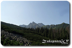
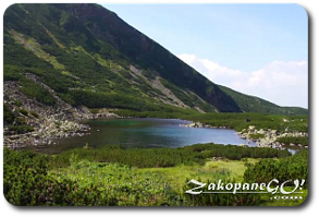
We see the sumit of Koszysta and the ridge along which the toughest trail in the Tatras runs – “Orla Perć” (“Eagle Path”). After an hour of hiking we reach the place where the black trail splits off, and we wander further along an extensive plateau, reaching the Czerwony Staw (Red Lake). In this part, the valley is surrounded by Panszczyca, the slopes of Zółta Turnia (Yellow Crag), and further on a section of “Orla Perć” from Skrajny Granat (2225 m above sea level) to Krzyzne Pass, while to the left side we have Koszysta and Wielka Kopka.
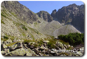
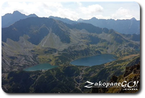
Higher up, the mountain pine floor ends and we wander the stony, dark wasteland. Buczynowe Turnie, which are part of the ridge, along which the trail “Orla Perć” runs, are especially impressive. The trail gradually ascends, the higher, the more steeper. The approach is quite tiring. We reach Krzyzne Pass around 3 hours after leaving the shelter. Fantastic panorama of the High Tatras and the stunning view of the Dolina Pięciu Stawów Polskich (Five Polish Lakes Valley) and Siklawa waterfall. Continue on the same color trail to the shelter in the Five Polish Lakes Valley or follow red for the toughest trail in the Tatras – “Orla Perć”.