Ornak – Ridge
![]()
![]()
Difficulty Level: *
Walking Time: 3h 45′ (6,0 km)
![]() 854m (2802ft)
854m (2802ft)
![]() 110m (361ft)
110m (361ft)
Climbing Features – NO
Highest Point: Ornak – 1867m (6125ft) a. s. l
From Wyznia Chocholowska Gate to Iwanowka Glade, follow the yellow trail along with the black trail running in the direction of Starorobocianska Valley. A gentle climb up to Iwniacka Valley and after an hour we are on Iwaniacka Pass (1459 m). From the pass we have a beautiful view of the Kominiarski Wierch and Tomanowy Wierch to the east of us.
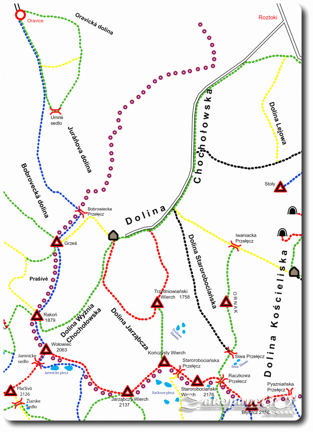
Take a right, heading for the green trail and enter the dense forest. Initially fairly flat, then ever increasing in steepness of the approach, we walk to Suchy Ornaczanski Wierch. It will take us almost half the time it would take to overcome the whole Ornak ridge. On the said stretch there is a rise in altitude of almost 400 m. The exhaustive journey brings us through an increasingly scarce forest onto hillside fields of mountain pine, rock debris and clearing below Suchy Ornaczanski Wierch, revealing a magnificent panorama towards both Chocholowska Valley and Koscieliska Valley, which are separated by the Ornak ridge. Among the increasingly rare dwarf pine, the path turns left and leads to of the aforementioned summits. Extensive glades and clumps of dwarf pine appear before us. From this point you can already see the entire course of the trail, which we still have to navigate, as it runs entirely along all the peaks belonging to the Ornak. The trail appears beautiful; a narrow, white and winding path over distant mountain tops.
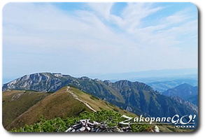
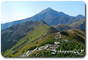
For the next 15 minutes we walk along an almost completely flat path, from which we still have great views in all directions.The Ornak summit, which we see before us, is entirely covered with small stones, so it stands out from the others, belonging to this cordillera. But before we get to the top of Ornak, take a peek down. On the right: a very light, bright green grass that looks different from everywhere, creating a sort of flowing, very thick liquid cover. It looks like dozens of small waves, which together form a set of small steps. Soon after, we reach the summit.From Ornak, we descend down a steep hill to Ornaczańska Przełecz (Ornaczanska Pass – 1795 m). From the point where you can see the entire pass, we have a view on the whole trail. A narrow path continuously leads along the ridge, throughout the entire length of the descent. Looking up, you can already see Siwe Skaly (Gray Rocks) as three jagged, vertical, dark rocks. The descent to the pass leads through grassy clearings. The terrain only becomes rockier, where the path widens slightly. After summiting this section, we see Siwe Skaly (Gray Rocks). It is a short crossing, but you have to squeeze between the rocks. While descending, you can see two distinctive rows of vertically protruding rocks off the trail behind you, on a steep hill to the west side, resembling plates on the back of a Stegosaurus. We begin to approach the last rise before Siwa Przełecz (Gray Pass), 15 minutes later reaching the turning for the trail leading from Dolina Starorobociańska (Starorobocianska Valley), along which we can return to the starting point of our expedition.