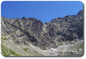
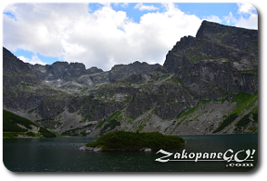
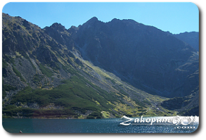
Czarny Staw (Black Lake) – Granaty Peaks
![]()
![]()
![]()
![]()
Difficulty Level: ** or ****
(Kulczynskiego Couloir)
Walking Time: 3h 50′ (3,3 km)
![]() 489m (2021ft)
489m (2021ft)
![]() 626m (2021ft)
626m (2021ft)
Climbing Features – Metal chains & brackets
Highest Point: Zadni Granat – 2240m (7349ft) a. s. l
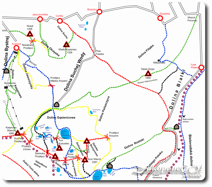
From shelter to the crossroads near the Zmarzły Staw (Frozen Lake) we follow the blue trail leading to the Zawrat Pass and further on the yellow trail onto Kozia Przełecz (Chamois Pass).
After a quarter of an hour at a fork in the trails in the Kozia Dolinka (Chamois Valley) we peel off onto the green trail leading up to Zadni Granat. The path ascends for a few minutes among the rock debris leading to the next fork.
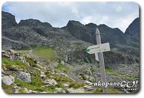
Here we have a few options for our journey ahead: the green trail is easier whereas the black trail involves more climbing, therefore the former should be advised to people suffering from agoraphobia.
Option 1 – green trail to Zadni Granat (easy)
![]()
A green marked path to Zadni Granat peels off to the left from the bottom of Kozia Dolinka (Chamois Valley), while the black trail heads right leading straight to Żleb Kulczuńskiego (Kulczynski Couloir). An easy, but tiring, steep path leads up a grassy slope in zigzags. We approach the rocky terrain after a short distance, encountering some minor obstacles. Above, a meandering path leads among grassy area.
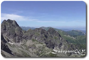
The trail is partially paved with stone steps, however, considerable sections of the path are covered with gravel.Just below the peak, the trail mellows out. At the top, the green marked trail connects to the red-labeled “Orla Perć” (“Eagle Path”). Turning left along a short section of the red trail, an easy section of the ridge leads us to the highest of the three Granat peaks – Zadni. The surrounding landscape is phenomenal!
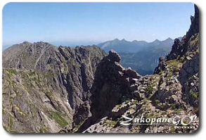
From the crossroads at Zmarzły Staw (Frozen Lake) it is usually not more than one and a half hours trek. A further hike leads along the ridge, one of the easier sections of “Orla Perć”. We descend to the Pośrednia Sieczkowa Pass to then again hike uphill over large boulders, bypassing Posredni Granat. At some point we enter the narrow path that ends on a cliff, so we turn sharp to the left, climbing down large boulders. Further on, another descent over irregular rocky grounds. We come to a narrow ledge, which features brackets and should be crossed very carefully. A little further, we come to a massive gap and use the chain provided to move to the other side.
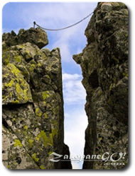
For the less daring, however, there is the option to bypass this section. A narrow bed of rocks on the left side of the chain allows us to do so. We at now at Skrajna Sieczkowa Pass. To the west falls Żleb Drege`a (Drege’a Couloir) which, at first glance, is gentle when, in fact, it is deadly, undercut by a cliff .Under no circumstances should you deviate from the marked route! Fatalities have been noted in this area!
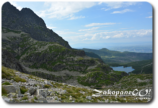
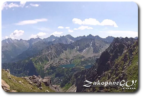
We reach Skrajny Granat easily, up the rocky chute, about twenty minutes after the departure from Zadni Granat. From there, we continue along Orla Perc, but you must take into account that the further part of it is very difficult and will only be able to go down to the valley after reaching Krzyzne Pass. We are guided by the now yellow signs, down towards Czarny Staw (Black Lake), visible below, zigzag along brittle terrain overcoming large boulders, eventually crossing a narrow lane where there are brackets and chains attached to help us navigate the rocks. We wander among the rocks on the steep terrain and then traverse the slope of Zółta Turnia (Yellow Crag). As the path relents, we walk among the mountain pine and the stone steps to reach the intersection with the blue trail, along which we can return to the shelter on Hala Gasienicowa.
Option 2 – black trail along Kulczynski Couloir (hard)
![]()
To the left, green marked path to Zadni Granat, while we head on towards Kulczynski Couloir following the black signs. After crossing the flat bottom of the valley, we come to the scree falling from the rocky massif. We ascend to the foot of the characteristic Rysa Zaruskiego. At the foot of the wall, even in midsummer, the area is often covered in snow, which may hinder our passage. The trail ascends along the wall, leading a few dozen metres along a damp gully and then turns hard to the left. A 15-minute climb follows, which includes a number of chains and brackets. We are now at the foot of Żleb Kulczyńskiego (Kulczynski Couloir), just beyond the border of Kozia Dolinka (Chamois Valley). Extra care should be taken when crossing the gravelly terrain. After another few minutes, the black trail connects to the red-labeled “Orla Perć”. We turn left and ascend using the many climbing aids provided, eventually reaching the point below Czarne Sciany (Black Walls) which leads us out to Zadni Granat. The latter part of the journey is as described in option 1.